SCROLL DOWN
Geospatial AI Services
We create geospatial AI solutions that transform location data into actionable insights, helping businesses plan more effectively, use resources more wisely, and achieve tangible results.


Why Geospatial AI Is Critical for Smarter Location-Based Decisions
Without intelligent geospatial analysis, organizations face location blindness, poor site selection, and missed opportunities. Geospatial AI transforms data into actionable insights that drive efficiency, reduce risks, and support smarter decisions.
Data-driven location strategy
Geospatial AI supports data-driven site selection by analyzing geographic, demographic, and market factors together. With geospatial intelligence, businesses can identify the most promising areas for expansion, store placement, or infrastructure projects.
Efficient resource allocation
GeoAI services enable organizations to allocate vehicles, teams, and assets where they create the most value. This helps reduce costs, improve routing, and boost service efficiency by ensuring resources are always used in the right place at the right time.
Smarter market expansion
With geospatial AI, businesses can spot emerging demand patterns and discover untapped markets. It turns spatial data into practical insights, helping organizations design more targeted strategies, expand, and capture new opportunities.
Predictive risk management
Geospatial AI solutions help organizations predict and prepare for location-based risks, from environmental hazards to infrastructure challenges. This allows companies to address threats, minimize financial losses, and safeguard long-term investments.
Geospatial AI Services We Provide
We provide geospatial AI services that help businesses turn geographic data into actionable insights for better planning, smarter decisions, and greater efficiency.
-
Satellite & drone imagery analytics
Our team designs and develops geospatial AI solutions that process satellite and drone imagery to detect, classify, and monitor objects at scale. This enables precise mapping, environmental monitoring, and infrastructure analysis.
-
Custom AI model development
We create tailored geospatial computer vision models for unique business needs. From rare object detection to complex segmentation tasks, our development team builds solutions that extract actionable insights from imagery data.
-
Object & change detection
Within geospatial AI services, we develop solutions that automatically identify objects, track changes in imagery over time, and detect anomalies. They help organizations monitor assets, manage land use, and maintain operational efficiency.
-
GIS integration & API access
Requestum team integrates geospatial AI solutions into existing GIS and enterprise systems through APIs and data pipelines. This approach makes spatial insights accessible directly within the tools companies already use every day.

Geospatial AI Use Cases by Industry
Geospatial Artificial Intelligence is applied across many fields, helping organizations boost efficiency and safety. It supports smarter farming, faster crisis response, and more resilience.
Geospatial AI Use Cases by Industry
Geospatial Artificial Intelligence is applied across many fields, helping organizations boost efficiency and safety. It supports smarter farming, faster crisis response, and more resilience.

Urban planning and smart cities
GeoAI helps city planners analyze growth patterns, optimize land use, and improve infrastructure. It supports smarter public services, efficient transport networks, and more sustainable cities.

Agriculture and land management
With GeoAI, farmers can monitor soil and crop health, optimize planting, and practice precision farming. This boosts yields, reduces resource waste, and supports sustainable agriculture.

Transportation and logistics
Geospatial AI improves logistics by mapping traffic, predicting demand, and optimizing delivery routes. It helps companies manage fleets, cut fuel costs, and enhance customer satisfaction.

Energy and resource management
GeoAI enables smarter energy use by analyzing consumption patterns and optimizing resource distribution. It supports renewable energy adoption and efficient, sustainable resource management.

Real estate and property management
Geospatial AI solutions deliver insights for property valuation, zoning, and market analysis. It helps businesses and investors make better decisions, reduce risks, and increase value.

Insurance and risk assessment
GeoAI strengthens insurance with spatial risk analysis and faster claims processing. With it, insurers can optimize pricing, assess risks more accurately, and improve customer trust.
Urban planning and smart cities
GeoAI helps city planners analyze growth patterns, optimize land use, and improve infrastructure. It supports smarter public services, efficient transport networks, and more sustainable cities.
Agriculture and land management
With GeoAI, farmers can monitor soil and crop health, optimize planting, and practice precision farming. This boosts yields, reduces resource waste, and supports sustainable agriculture.
Transportation and logistics
Geospatial AI improves logistics by mapping traffic, predicting demand, and optimizing delivery routes. It helps companies manage fleets, cut fuel costs, and enhance customer satisfaction.
Energy and resource management
GeoAI enables smarter energy use by analyzing consumption patterns and optimizing resource distribution. It supports renewable energy adoption and efficient, sustainable resource management.
Real estate and property management
Geospatial AI solutions deliver insights for property valuation, zoning, and market analysis. It helps businesses and investors make better decisions, reduce risks, and increase value.
Insurance and risk assessment
GeoAI strengthens insurance with spatial risk analysis and faster claims processing. With it, insurers can optimize pricing, assess risks more accurately, and improve customer trust.
Our Case Studies
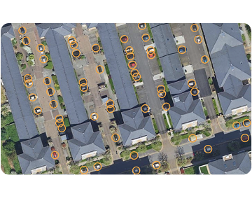
Detection of Cars on Overhead Images
The primary aim of this project was to calculate the density of cars in a chosen region. This analysis was crucial for understanding traffic patterns, aiding urban planning, and developing smart city initiatives.
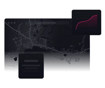
Demand Forecasting Solution for Transportation Services
By blending advanced machine learning, geospatial analysis, and real-time data integration, this solution improved daily operations and allowed transport companies to respond to fluctuating demand.
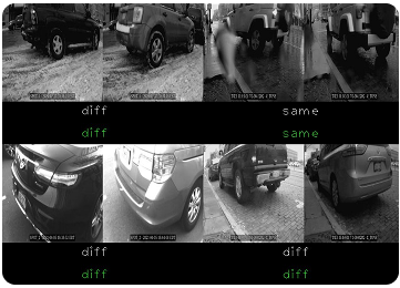
AI-Based Parking Surveillance
We managed to create universal solution for different facilities that caters the decision process whether to approve or reject the violation according to the established rules.
Our Process for Developing Geospatial AI Solutions
We follow a systematic approach to turning geographic data into actionable insights that enable smarter location-based decisions. Each Geospatial AI project moves through well-defined stages, ensuring successful results and long-term value.
Spatial data assessment
We assess your geographic datasets, identify gaps, and define requirements for a tailored geoAI solution. This ensures that the foundation for your project is strong and aligned with business objectives.
Project planning and design
At this stage, our team translates requirements into a detailed roadmap that outlines scope, milestones, and priorities. We establish a clear plan for building a solution that stays on track and meets expectations.
AI model development
Requestum team designs and trains custom geospatial AI models that address your unique analysis needs. These models form the core of your geoAI solution, enabling accurate insights and smarter decision-making.
Integration and validation
Our specialists integrate the developed geoAI solution with your existing systems and workflows. Rigorous validation ensures data accuracy, smooth performance, and reliable visualization capabilities.
Deployment, monitoring, and support
After deployment, Requestum experts monitor your geoAI solution to maintain stability and performance. We provide continuous updates and support to ensure it evolves alongside your business needs.
Why Choose Us for Geospatial AI Services
Advanced AI expertise
We leverage our expertise to create solutions powered by the latest computer vision and AI technologies. This keeps our clients ahead in innovation, efficiency, and competitiveness.
Quality and accuracy
We develop software solutions with precision and reliability, always tailored to your requirements. Our standards ensure every project delivers measurable results.
Experience across industries
The Requestum team has implemented solutions for various industries. Projects we have delivered demonstrate our ability to create software that meets specific industry needs.
What our customers say
Discover testimonials from our clients and learn why they trust us.
What our customers say
Discover testimonials from our clients and learn why they trust us.


James Hodson
CEO, MySyla
Requestum works more efficiently during a war than most other teams work in peacetime. The quality of development work is excellent on all fronts. Despite setbacks with the team needing to move around the country to stay safe, air raid sirens, and Internet outages, the team has never missed a deadline or gone a day without finding a way to communicate. Requestum genuinely cared about making sure the final product was exactly what was needed. The team improved the features in ways that we could never have come up with ourselves. They obviously enjoy working together, and have created an excellent team spirit and work ethos.

Danny van de Griend
CEO, Cecil Alliance
Requestum was always accessible and ready to discuss new ideas. Every suggestion that i have made during the project was carefully considered, and went through feasibility pipeline which worked perfectly for my platform.


VERIFIED
Review on

Ben Clink
Head of Customer & Digital, South Sydney Rabbitohs
I can confidently call Requestum a reliable partner who delivered an easy-to-use, feature-rich app on time and within budget. The team worked collaboratively, accommodated all requests and scope changes, and communicated effectively throughout the project. They went the extra mile to understand and respond to the requirements.

GianBruno Torrano
Vice President, Soft-net Sp. Z o.o.
The team is readily available and regularly checks in. Their responsive nature sets them apart and supplements continued engagement. Requestum has facilitated a positive customer experience by understanding the requirements and successfully implementing a number of complex backend functionalities.

Ruairidh Galbraith
Digital project manager, Uncommon Knowledge
The team at Requestum is very friendly, efficient and professional. We have worked with them on more than one occasion and are very pleased with the quality of service. So far we’ve made back the money that we spent in less than eight months of launching.
Frequently Asked Questions
-
What types of data does geospatial AI use?
Geospatial AI relies on a wide range of data sources to deliver meaningful insights. These include satellite imagery, sensor streams, point clouds, geotagged text, and video. Combining different data types allows for deeper analysis of spatial patterns, relationships, and trends.
-
How accurate are geospatial AI predictions?
The accuracy of geospatial AI predictions depends on both the quality of the data and the specific application. With rigorous validation and optimization, geospatial AI development services can achieve 85–95% accuracy for tasks such as site selection and location forecasting.
-
How can businesses benefit from GeoAI?
Businesses gain multiple advantages from GeoAI, from predictive modeling to real-time decision-making. By applying custom GeoAI services, companies can forecast demand, streamline operations, and allocate resources more effectively. Ultimately, GeoAI helps organizations make smarter strategic choices and improve efficiency.
-
What industries benefit most from geospatial AI services?
The geospatial AI solutions we develop are applied across industries, including retail, logistics, agriculture, real estate, utilities, urban planning, and more. These sectors benefit from spatial analysis and location intelligence that enhance planning, performance, and sustainability.
-
What is the cost for implementing GeoAI?
The cost of implementing GeoAI depends on the project’s scope, complexity, and level of customization. Since every GeoAI initiative is unique, we provide a tailored estimate. Get in touch with us to discuss your requirements and receive an accurate quote.
Our contacts
We are committed to ensure quality in detail and provide meaningful impact for customers’ business and audience.
-
UA Sales Office:
sales@requestum.com -
HR Team:
talents@requestum.com -
Estonia
15551, Harju maakond, Tallinn, Lasnamäe linnaosa, Sepapaja tn 6
-
Ukraine
61183 str. Rodnikovaya, 9a, ap. 55a, Kharkiv, Ukraine
-
Switzerland
6313, Seminarstrasse, 5, Menzingen